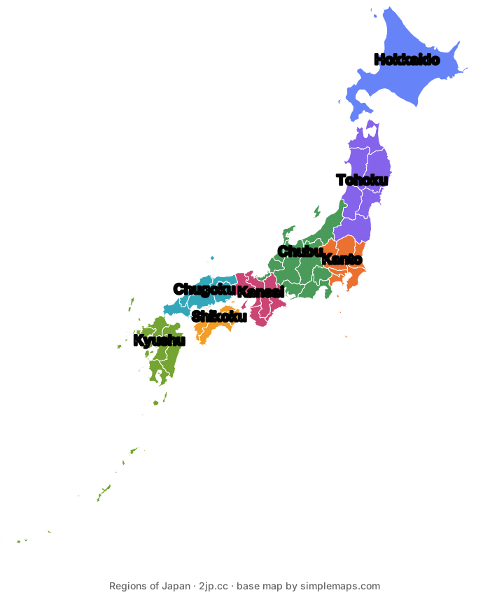
Japan is a 3,000 km chain of islands, three-quarters mountainous, divided into 8 regions and 47 prefectures. Click any region to see what it contains and what it's known for.
OVERVIEW
This page answers one question: what does Japan actually look like, and how is it divided? Start with the interactive region map, then read the geography that explains why Japanese cities, weather, and travel routes are shaped the way they are.
REGIONS
Select a region to see its prefectures and what it is known for.
Real prefecture outlines, grouped into the 8 regions. Tokyo’s Izu and Ogasawara islands lie outside the visible area. Base map by simplemaps.com
The northernmost main island, separated from Honshu by the Tsugaru Strait (crossed by the Seikan undersea tunnel).
Hokkaido — Capital: Sapporo
Japan's snowiest, most sparsely populated prefecture — ski resorts, dairy farms, and the country's biggest winter festival.
The northern third of Honshu, directly south of Hokkaido.
Aomori — Capital: Aomori
Apple orchards, the Nebuta summer festival, and Hirosaki's castle park.
Iwate — Capital: Morioka
The Hiraizumi temple complex, the Sanriku coast, and wanko-soba noodle challenges.
Miyagi — Capital: Sendai
Matsushima Bay's pine-covered islets, grilled beef tongue, and the Tanabata star festival.
Akita — Capital: Akita
The Kanto pole-lantern festival, Nyuto's remote hot springs, and the native Akita dog breed.
Yamagata — Capital: Yamagata
Zao's ski slopes and frost-covered 'snow monsters', cherries, and the cliffside Yamadera temple.
Fukushima — Capital: Fukushima
The old castle town of Aizuwakamatsu, peach orchards, and the Bandai-Asahi mountains.
East-central Honshu, on the Pacific coast.
Tokyo — Capital: Tokyo
The national capital — Shibuya, Shinjuku, Asakusa, and Tokyo Skytree.
Kanagawa — Capital: Yokohama
The port city of Yokohama, Kamakura's coastal temples, and Hakone's hot springs.
Saitama — Capital: Saitama
A Tokyo commuter prefecture, with Kawagoe's preserved 'Little Edo' old town.
Chiba — Capital: Chiba
Narita International Airport, Tokyo Disney Resort, and the Boso Peninsula's beaches.
Ibaraki — Capital: Mito
Kairakuen's plum blossoms, natto fermented soybeans, and Mt. Tsukuba.
Tochigi — Capital: Utsunomiya
Nikko's shrines and waterfalls, and Utsunomiya's grilled gyoza dumplings.
Gunma — Capital: Maebashi
Kusatsu's hot-spring town and the UNESCO-listed Tomioka Silk Mill.
The wide middle of Honshu, spanning coast to coast.
Niigata — Capital: Niigata
Rice and sake country, heavy winter snowfall, and Sado Island.
Toyama — Capital: Toyama
The Tateyama Kurobe Alpine Route, glass art, and firefly squid fishing.
Ishikawa — Capital: Kanazawa
Kenrokuen Garden, gold-leaf crafts, and Kanazawa's samurai and geisha districts.
Fukui — Capital: Fukui
A major dinosaur-fossil museum, the Eiheiji Zen temple, and the Tojinbo cliffs.
Yamanashi — Capital: Kofu
Close-up Mt. Fuji views from the Fuji Five Lakes, plus vineyards and wine.
Nagano — Capital: Nagano
The Japanese Alps, Zenkoji temple, and host of the 1998 Winter Olympics.
Gifu — Capital: Gifu
The gassho-roofed villages of Shirakawa-go and Takayama's preserved old town.
Shizuoka — Capital: Shizuoka
Mt. Fuji's southern base, green tea plantations, and Izu Peninsula's hot springs.
Aichi — Capital: Nagoya
Nagoya Castle and Japan's automobile-manufacturing heartland (Toyota).
West-central Honshu, around Osaka Bay.
Mie — Capital: Tsu
The Ise Grand Shrine, Matsusaka beef, and Ago Bay pearl cultivation.
Shiga — Capital: Otsu
Home to Lake Biwa, Japan's largest lake.
Kyoto — Capital: Kyoto
Japan's former imperial capital — historic temples, shrines, and geisha districts.
Osaka — Capital: Osaka
Street food, Dotonbori's neon nightlife, Osaka Castle, and comedy culture.
Hyogo — Capital: Kobe
Himeji Castle, Kobe beef, and the Arima hot-spring town.
Nara — Capital: Nara
Todaiji temple, free-roaming deer, and Japan's first permanent capital.
Wakayama — Capital: Wakayama
The Koyasan temple town and the Kumano Kodo pilgrimage trails.
The western end of Honshu, between the Sea of Japan and the Seto Inland Sea.
Tottori — Capital: Tottori
The Tottori Sand Dunes and pear orchards.
Shimane — Capital: Matsue
Izumo Taisha, one of Japan's oldest shrines, and the Adachi Museum's landscape garden.
Okayama — Capital: Okayama
Korakuen Garden, Kurashiki's canal-side old quarter, and peach growing.
Hiroshima — Capital: Hiroshima
The Peace Memorial Park and Miyajima's 'floating' torii gate.
Yamaguchi — Capital: Yamaguchi
The Kintaikyo Bridge, Akiyoshido limestone cave, and fugu pufferfish cuisine.
The smallest of the four main islands, south of Honshu across the Seto Inland Sea, linked by three bridge routes.
Tokushima — Capital: Tokushima
The Awa Odori dance festival and the Naruto whirlpools.
Kagawa — Capital: Takamatsu
Japan's udon-noodle capital, plus the classical Ritsurin Garden.
Ehime — Capital: Matsuyama
Dogo Onsen, among Japan's oldest hot springs, and mikan citrus orchards.
Kochi — Capital: Kochi
Katsurahama beach, bonito fishing, and Ryoma Sakamoto heritage sites.
The southwestern main island, plus the Okinawa island chain a further ~700 km southwest.
Fukuoka — Capital: Fukuoka
Tonkotsu ramen and Hakata's open-air yatai food stalls.
Saga — Capital: Saga
Arita porcelain, one of Japan's oldest ceramic traditions, and a hot-air balloon festival.
Nagasaki — Capital: Nagasaki
A historic foreign-trading port — Glover Garden and the Huis Ten Bosch theme park.
Kumamoto — Capital: Kumamoto
Kumamoto Castle and Mt. Aso's volcanic caldera.
Oita — Capital: Oita
The Beppu and Yufuin hot-spring towns.
Miyazaki — Capital: Miyazaki
Takachiho Gorge and surf beaches on the Pacific coast.
Kagoshima — Capital: Kagoshima
The active Sakurajima volcano, Yakushima's ancient forest, and sweet-potato shochu.
Okinawa — Capital: Naha
Ryukyu culture, Shuri Castle, and coral-reef beaches.
QUICK FACTS
Figures are drawn from Japanese government sources (Geospatial Information Authority, Statistics Bureau) as of 2023–2025. Statistics are periodically revised — check the official source before citing exact numbers.
ISLAND CHAIN
Japan is an archipelago off the eastern edge of Asia, stretching roughly 3,000 km from the sub-arctic north of Hokkaido to the subtropical islands of Okinawa. Because it is long from north to south but narrow from east to west, the climate changes dramatically along its length: in the same week, Hokkaido can be under deep snow while Okinawa is warm enough for the beach. The whole country still uses a single time zone.
MOUNTAINS AND COAST
Roughly three-quarters of Japan's land is mountainous, and about two-thirds is covered in forest. A spine of mountains runs down the middle of the main island of Honshu, including the Japanese Alps, which rise above 3,000 m. Because so little land is flat, almost all large cities, farmland, and rail lines are squeezed onto narrow coastal plains — the Kanto Plain around Tokyo is the largest of them.
VOLCANOES AND HOT SPRINGS
Japan sits where several tectonic plates meet, on the Pacific 'Ring of Fire'. That is why the country has over a hundred active volcanoes, frequent earthquakes, and thousands of natural hot springs (onsen). The same geology that makes earthquake-resistant building codes necessary also gives Japan its volcanic scenery, crater lakes, and hot-spring resort towns.
TWO COASTS
The mountain spine splits Honshu into two climatically distinct sides. The Sea of Japan side (the 'back' side) receives some of the heaviest snowfall on Earth in winter, as cold Siberian air picks up moisture crossing the sea. The Pacific side, where Tokyo, Nagoya, and Osaka sit, gets drier, sunnier winters — but takes the brunt of the typhoon season from roughly August to October.
REGIONS EXPLAINED
Japan's 47 prefectures are the actual administrative units. The 8 regions below are conventional groupings rather than a level of government — but they are what timetables, weather forecasts, rail passes, and travel guides use, so knowing them makes planning much easier.
DOWNLOADS
FAQ
Japan has 47 prefectures, which are the real administrative divisions. They are conventionally grouped into 8 regions — Hokkaido, Tohoku, Kanto, Chubu, Kansai, Chugoku, Shikoku, and Kyushu (with Okinawa usually counted alongside Kyushu). The regions are not a level of government, but they are used constantly in weather reports, rail passes, and travel planning.
From north to south: Hokkaido, Honshu (the largest, holding Tokyo, Kyoto, and Osaka), Shikoku, and Kyushu. Beyond these, Japan counts roughly 14,125 islands in total following a 2023 recount by the Geospatial Information Authority of Japan — the older figure of 6,852 you may still see was based on a 1987 survey with a different counting method.
Japan sits at the meeting point of several tectonic plates on the Pacific Ring of Fire. The collision of those plates pushes the land upward, which is why roughly three-quarters of the country is mountainous and why it has over a hundred active volcanoes, frequent earthquakes, and thousands of hot springs.
Most first trips combine Kanto (Tokyo) and Kansai (Kyoto, Nara, Osaka), because they hold the biggest cities and the highest concentration of famous sights and are connected by about 2.5 hours on the Tokaido Shinkansen. Add Chubu if you want mountains and Mt. Fuji, Hokkaido for snow, or Okinawa for beaches.
No. Despite stretching about 3,000 km from north to south, the entire country uses a single time zone, Japan Standard Time (UTC+9), and does not observe daylight saving time.
The outlines are real prefecture boundaries, based on a public-domain-licensed vector map from simplemaps.com, coloured by region. It is drawn for reading at a glance, so small islands and fine coastal detail are generalised, and Tokyo's far-flung Izu and Ogasawara islands are outside the visible area. It is not a survey map and carries no political claim about disputed territory.